Australia So Much to See


< Previous
travasmtc2008039001.gif
Next page >
Home
Travelogues
Tips and Hints
Lists and Links
Q & A
Contact
< Previous
travasmtc2008039001.gif
Next page >
Home
Travelogues
Tips and Hints
Lists and Links
Q & A
Contact
Home > Travelogues > 2008 Travelogues Index The Great Central Road > Giles Weather Station history

1. The Giles Weather Station was established in 1956 by the Weapons Research Establishment (now known as the Defence Science and Technology Organisation), a division of the Department of Defence. The first weather observations were transmitted from the station by radio on 2 August 1956.


2. The purpose of the station was to provide weather data for the UK atomic weapons tests at Emu Plains and Maralinga. It was also used to support the rocket testing program based at Woomera, being conveniently positioned at the edge of and about halfway down the testing range. Giles Weather Station was transferred from the Department of Defence to the Bureau of Meteorology in 1972.


3. The station has a staff of four who run it on a six-month tour. The staffing is arranged by the South Australian Regional Office of the Bureau of Meteorology and the Observing staff come from various Bureau offices throughout Australia. The station has satellite and telephone communications facilities, and hydrogen gas is produced on site for weather balloon flights.


4. Situated about 750 kilometres west-southwest of Alice Springs, just over the West Australian Border, on the edge of the Gibson Desert, south of the Rawlinson Range. The area was occupied by nomadic aborigines at the time the station was established, but there were no other settlements in the area. The station was named in honour of Ernest Giles, who explored the area in the 1870's. The Warakurna Aboriginal Community has become established nearby with their own power supplies, store, school and a Roadhouse on the Gunbarrel Highway which provides accommodation and food for travellers. An all-weather airstrip provides ready access for mail, passengers and the Flying Doctor.


5. Giles is the resting place of the Caterpillar grader which was used to build the Gunbarrel Highway, and other roads in the area. This grader was first used in the Emu Plains and Maralinga areas from 1953 to 1955. It was then assigned to the Gunbarrel Road Construction Party, led by surveyor Len Beadell from the Department of Defence, commencing work in the area in 1955. This grader was used to construct of 6,000 kilometres of road through the Great Victoria, Gibson and Great Sandy deserts, starting with the road to Giles. As each section of the road was graded five times, the total distance worked was in excess of 30,000 kilometres. The Gunbarrel Highway was the first east-west link across Central Australia. The grader ceased its working life, at Giles, on 22 November 1963; and has been preserved there since that time. Len Beadell was also known as an artist and author, and has provided Giles with interesting murals on the walls of the mess building - a common talking point for many visitors to the station.


6. Giles Weather Station is a modern fully equipped station which carries out a full range of meteorological observations, including upper atmosphere observations using balloon flights and radar tracking. It is the only staffed weather station in an area of about 2.5 million square kilometres. Its location near the core of the subtropical jetstream makes the station vital for forecasting over most of eastern and southeasternAustralia, particularly for rain. In summer it provides data on convective situations for the assessment of severe storms etc. Its central continental location makes it a key station for climate measurement and forecasting purposes over much of Australia, and also for the "local" weather, be it for places such as Uluru and Alice Springs, or for aircraft operations to aboriginal communities. Giles provides useful meteorological data in a remote region to the west and northwest of most major population centres of Australia. This data is vital for global and local computer models for forecasting, and is particularly useful for international air flights.


7.For many years the weather data collected at Giles was transmitted by HF radio, which posed difficulties when radio reception was poor. Since 1986, data has been transmitted much more reliably via landline or satellite to Melbourne where it is included in the national and international networks.


Back to top ^

Use your browser back button to return to the page you were reading

Giles Weather Station


Update: With further staffing reductions, tours of the Giles Weather Station are no longer available.  The visitor room will remain open to the public, and the weather balloon releases can be observed from the car park.  Times for the balloon releases remain the same as hereunder.


Please phone the station before you visit on 08 8956 7358 to see what is available.  Covid restrictions may apply 2020/2021.


Due to changes in staffing, these informative and interesting tours of the weather station have been changed.  Watching the release of the weather balloons will no longer be part of the tour and can only be seen from the car park.  This tour in its full form was the highlight of our trip across the Great Central Road.  See our traveloguehere


Media release from Bureau of Meteorology:


Guided tours of weather station are no longer available   


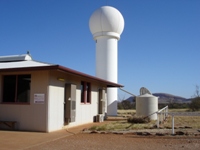
Weather balloon releases can be viewed daily, looking towards the radar tower, from the car park near the visitors centre, at the following times:        


Non Daylight Savings: 8:45am and 2:45pm. (South Aust. time)

Daylight Savings: 9:45am and 3:45pm. (South Aust. time)


Paul Lainio

Senior Meteorologist, Media and Community Relations

 15 November 2012 


Updated 4 May 2021

Giles Weather Station

History of Giles Weather Station published with the permission of South Australian Regional Office of the Bureau of Meteorology
 

tn_giles20.jpg tn_giles19.jpg tn_giles18.jpg
Copyright (C) 2013 AustraliaSoMuchtoSee.com. All rights reserved
Continue reading >
Want to know more?
Ask us